
The Nazca Lines
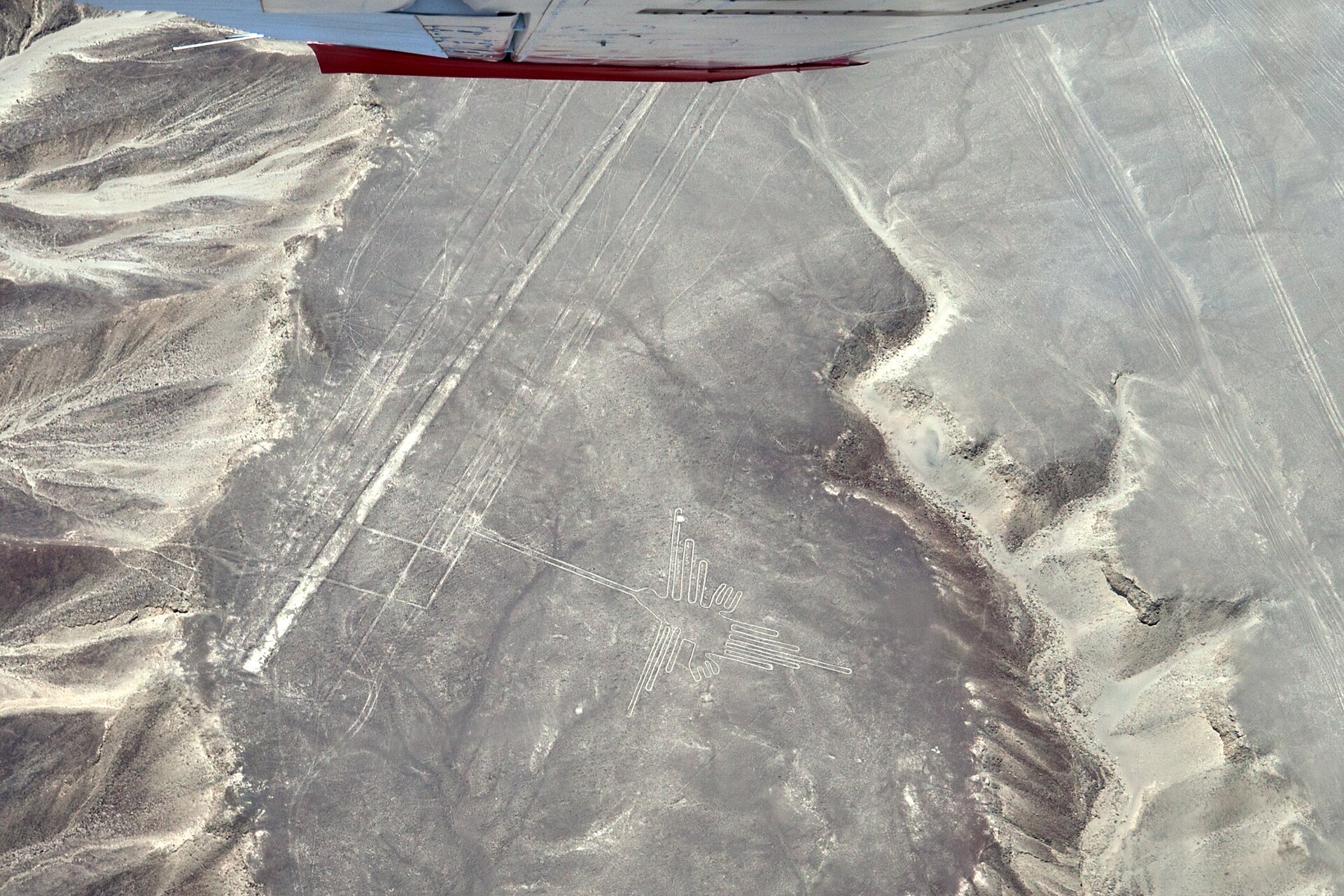
The Nazca Lines are a vast set of geoglyphs — animals, plants, and geometric shapes — etched into the desert of southern Peru by the Nazca culture roughly 2,000 years ago, made by clearing dark surface stones to reveal pale ground beneath. Archaeologists link them to ritual processions and water-and-fertility ceremonies; a 2024 AI-assisted survey nearly doubled the known count of figurative geoglyphs. A UNESCO World Heritage Site since 1994.
Our read
Evidence — 10 claims
7 supported · 2 resolved · 1 open
Sources — 5
5 sources · court / archive + academic + journalism
Unresolved
The record does not support a single durable explanation.
- SupportedThe Nazca Lines were made by the Nazca (and earlier Paracas) culture roughly 2,000 years ago by clearing dark surface stones to reveal pale caliche beneath.
- ResolvedUNESCO inscribed the Lines and Geoglyphs of Nasca and Palpa as a World Heritage Site in 1994, citing them as 'among archaeology's great enigmas.'
- SupportedA 2024 PNAS study by Sakai et al. using AI-assisted analysis identified 303 new figurative geoglyphs, nearly doubling the previously known count.
- SupportedThe newly identified 2024 geoglyphs are mostly smaller human and animal figures located near ancient settlements and pilgrimage routes.
- SupportedThe astronomical calendar hypothesis (Reiche/Kosok) was statistically tested by Gerald Hawkins in 1967 and found no significant celestial correlation.
- SupportedThe archaeological consensus links the geoglyphs to ritual processions and water-and-fertility ceremonies.
- ResolvedThe 'ancient astronaut' / extraterrestrial explanation is classified as pseudoarchaeology and rejected by the archaeological community.
- SupportedExperimental archaeology has demonstrated the lines could be made with basic surveying tools and organized labor.
- SupportedA German mathematician was linked to damage at the Nazca site.
- OpenThe specific function or functions of the geoglyphs — ritual, astronomical, water-marking, or other — remains contested among researchers.
What remains unexplained
Construction method and makers are settled. The specific purpose of the lines — ritual procession, water ceremony, astronomical reference, or some combination — remains genuinely open, and the 2024 AI survey adds data without closing the question.
- 01Why the Nazca built figures only fully visible from altitude — whether intentional or incidental — is unresolved.
- 02The relative weight of ritual-procession vs. water-fertility vs. astronomical functions is still debated among archaeologists.
- 03The 2024 AI survey nearly doubled the known geoglyph count; full analysis of the new figures and what they imply about site use is ongoing.
Nazca Desert, southern Peru. Roughly 2,000 years ago, someone started moving rocks.
Not randomly — with intention. The Nazca culture cleared dark surface stones from the desert floor to expose the pale caliche beneath, etching lines, spirals, trapezoids, and figures into a canvas roughly 450 square kilometers wide. The result: a hummingbird with a 96-meter wingspan. A spider. A monkey with a coiled tail. Geometric lines that run for kilometers without deviation. All of it invisible in its full form unless you're above it — which the Nazca were not, in any conventional sense.
The UNESCO World Heritage Committee inscribed the site in 1994, citing the lines as "among archaeology's great enigmas" for their quantity, scale, and continuity. That's not a committee hedging. That's a committee accurately describing what's there.
What happened
The construction method is well understood and genuinely unimpressive in the best possible way: remove the reddish-brown iron-oxide-coated stones, pile them at the edges, reveal the yellowish ground beneath. No advanced technology required. The desert's near-zero wind and low rainfall preserved the result for two millennia. The Nazca — and the earlier Paracas culture — made these over centuries, not in a single burst of activity.
The archaeological and scientific consensus links the geoglyphs to ritual processions and water-and-fertility ceremonies. The leading interpretation isn't "astronomical calendar" — that was Maria Reiche and Paul Kosok's influential mid-20th century hypothesis — but Gerald Hawkins's 1967 statistical analysis found no significant celestial correlation, and it hasn't recovered as the consensus view since.
In September 2024, Yamagata University published a study in PNAS using AI-assisted analysis of high-resolution aerial imagery. The result: 303 new figurative geoglyphs identified, nearly doubling the previously known count. The AI model was trained on previously confirmed examples, then turned loose on the wider desert. Most of the newly identified figures are smaller — human forms, animals — and located closer to ancient settlements and pilgrimage routes, which fits the ritual-procession hypothesis.
The evidence
What's established: the lines are pre-Columbian, made by human hands, and preserved by an unusually stable desert climate. The figures include animals, plants, and geometric shapes at scales that require planning beyond what a single person could visually supervise from the ground — but not beyond what a team with basic surveying tools and a grid system could execute. Experimental archaeology has demonstrated this. No extraterrestrial assistance required, or evidenced.
The "ancient astronaut" framing — popularized in the 1960s by Erich von Däniken and still circulating — is classified as pseudoarchaeology by the archaeological community and rejected on evidentiary grounds. The argument that the lines could only serve as landing strips or signals to spacecraft doesn't survive contact with what the lines actually are: shallow scrapes in gravel, not load-bearing surfaces, and invisible from low altitude in their full form anyway.
One historical footnote worth knowing: a German mathematician was linked to damage at the site — a reminder that the lines' survival is not guaranteed. They're extraordinarily fragile.
What's still open
The construction method is solved. The makers are identified. The preservation conditions are understood. What remains genuinely contested is the why — the specific function or functions the geoglyphs served. Ritual procession routes, water-source markers, fertility ceremony spaces, and astronomical references have all been proposed. The 2024 AI survey's finding that newer figures cluster near settlements and paths adds data to the ritual-procession side. It doesn't close the question.
The scale still invites the obvious question: why build something you can only fully see from the air? The honest answer is that we don't know whether the Nazca intended them to be seen from above at all. The lines may have been about the act of walking them, not the view from outside them. That reframe doesn't make them less interesting. It makes them stranger.
Who made the Nazca Lines and when?
The Nazca Lines were created by the Nazca culture — and the earlier Paracas culture — in southern Peru roughly 2,000 years ago. They were made by clearing dark iron-oxide-coated surface stones to reveal the pale caliche beneath, a low-tech method that required planning and coordination but no advanced or extraterrestrial technology.
What do the Nazca Lines depict?
The geoglyphs include animals (a hummingbird, spider, monkey, condor), plants, human figures, and extensive geometric shapes including trapezoids and lines that run for kilometers. A 2024 AI-assisted survey published in PNAS identified 303 previously unknown figurative geoglyphs, nearly doubling the known count.
What is the leading explanation for why the Nazca Lines were made?
The current archaeological consensus links the lines to ritual processions and water-and-fertility ceremonies. The astronomical calendar hypothesis, proposed by Maria Reiche and Paul Kosok, was influential but statistically tested and not confirmed; it's no longer the consensus view.
Were the Nazca Lines made by aliens or ancient astronauts?
No — that explanation is classified as pseudoarchaeology and rejected by the archaeological community. Experimental archaeology has demonstrated that the lines could be produced with basic surveying tools and organized labor, and the 'landing strip' framing doesn't hold up: the lines are shallow gravel scrapes, not load-bearing surfaces.
How were so many new Nazca geoglyphs found in 2024?
Yamagata University researchers trained an AI model on previously confirmed geoglyphs and applied it to high-resolution aerial imagery of the wider Nazca desert. The September 2024 PNAS study identified 303 new figurative geoglyphs, most of them smaller human and animal figures located near ancient settlements and pilgrimage routes.
Why can the Nazca Lines only be seen from the air?
The figures are large enough — some spanning nearly 100 meters — that their full form isn't visible from ground level. Whether the Nazca intended aerial viewing is genuinely unknown; one serious interpretation is that the lines were designed to be walked as ritual paths, making the ground-level experience the point rather than the overhead view.
Ancient Mysteries
The Alignment of the Great Pyramid
The four sides of the Great Pyramid of Giza are aligned to the cardinal directions with an average error of about 4 arcminutes — better than 1/15th of a degree. Built around 2580–2560 BCE without iron tools, magnetic compasses, or modern surveying equipment. How its 4th-Dynasty builders achieved that precision is a real open archaeological question; the leading hypothesis (Glen Dash, 2017) is an Indian Circle method on the autumnal equinox, but it isn't the only candidate.
-2580
Ancient Mysteries
Göbekli Tepe
Carved limestone pillars in southeastern Turkey, raised around 9500 BCE by people who had no pottery, no writing, and no farms. Göbekli Tepe is older than Stonehenge by 6,000 years — and it suggests humans built monuments together before they settled down to grow food, flipping the standard story of how civilization began.
Ancient Mysteries
Rapa Nui's 30 Moai Workshops: The Centralized-Society Story Was Wrong
In November 2025, a Binghamton team flew 22,000 drone photos over Rano Raraku, built a centimeter-accurate 3D model, and mapped 30 independent moai carving workshops — parallel clan operations, not a centralized workforce. This dismantles Jared Diamond's ecocide collapse narrative, which had already been undermined by 2024 ancient-DNA work. A third turn: experimental physics shows the moai were walked upright on ropes to their platforms.
2025-11-26
UNESCO World Heritage Committee
1994
Inscribed as a World Heritage Site — Lines and Geoglyphs of Nasca and Palpa (ref. 700)
Recognized for outstanding universal value as a unique testimony of the Nasca culture; among archaeology's great enigmas for their quantity, scale, and continuity.
Archaeological and scientific consensus
ongoing
Authentic pre-Columbian geoglyphs made by the Nazca (and earlier Paracas) culture for ritual, water-and-fertility, and ceremonial purposes; firmly human-made
Precise function is still debated, but the 'ancient astronaut' / extraterrestrial explanation is classified as pseudoarchaeology and rejected.
Maria Reiche and Paul Kosok (historical hypothesis)
1940s onward
Proposed the lines as an astronomical calendar
Influential but not the modern consensus; Gerald Hawkins's 1967 statistical analysis found no significant celestial correlation. Included as historical context.
- Lines and Geoglyphs of Nasca and Palpa — UNESCO World Heritage Centre (ref. 700)Quoted or summarized under fair use — follow the link for the originalaccessed 2026-05-21
- Yamagata University — AI-accelerated Nazca survey nearly doubles the known figurative geoglyphs (September 2024)Quoted or summarized under fair use — follow the link for the originalaccessed 2026-05-21
- Sakai et al. — AI-accelerated Nazca survey nearly doubles the number of known figurative geoglyphs (PNAS, 2024)Quoted or summarized under fair use — follow the link for the originalaccessed 2026-05-21
- How a German Mathematician Took Responsibility for an Ancient Peruvian Artifact — Smithsonian MagazineQuoted or summarized under fair use — follow the link for the originalaccessed 2026-05-21
- Nazca lines — WikipediaCreative Commons — reuse allowed with attribution, share-alikeaccessed 2026-05-21
This account draws on publicly available sources and historical records. Report a factual error → How we source and correct →